Gassnova
 
Search button icon
  • Newsletter
  • News & media
  • Organisation
  • Contact
  • CCS dictionary
  • About Gassnova
    • Carbon Capture and Storage
    • CCS Knowledge
    • About Gassnova
  • Research and development (CLIMIT)
    • Main
    • Apply for funding
    • Projects
    • About CLIMIT Programme
    • CLIMIT`s Project Portfolio
    • CLIMIT Summit
    • USA & Norway Collaboration
  • Demo of CO2-capture (TCM)
  • Experience from Longship
    • Main
    • About Longship
    • Search in documents/reports from Longship
    • Timeline
View all posts in news News
Gult målebånd på blå overflate. Foto.

06.10.2023

SENSE: Millimeter precision of CO₂ storage monitoring

The SENSE project investigated how new monitoring techniques can contribute to safer CO2 storage. Promising results have emerged which may have international significance.

The project is supported through the international initiative, Accelerating CCS Technologies (ACT), which is part of the ERA NET Cofund. CLIMIT-Demo has contributed funding to the Norwegian research partners.

In the SENSE project, the team has developed a measurement technique that registers ground movements at millimeter level on land and at sea. Ground movement is related to pressure change in the storage reservoir and thus help operators to ensure a safe CO2 injection. Broad international participation with leading research environments and active industry participants has contributed positively to this project, emphasizes Kari-Lise from the CLIMIT programme, which follows several international initiatives under the auspices of ACT.

Portrett av prosjektleder Bahman Bohloli fra Norges Geotekniske Institutt (NGI). Foto.
Project leader Bahman Bohloli from the Norwegian Geotechnical Institute (NGI)

Three important findings

“SENSE answers important questions about how technological solutions can contribute to safe storage of CO2. We have developed technologies and modeling tools that are more effective than before, says project manager Bahman Bohloli from the Norwegian Geotechnical Institute (NGI). He goes on to say that testing of fiber optics in large-scale laboratory trials at NGI, in Germany and in the field in Japan has helped to confirm and secure the results of the project.

From the laboratory and field tests, we can conclude that “strain-sensing” fiber optic measurement technology shows the same accuracy, and that it is an effective technology for monitoring CO2 storage sites with to get insight on pressure change in reservoir.

Seks forskjellige ovaler i en sirkel som viser forskjellige deler av prosjektet. Illustrasjon.
Activities and methods used in the SENSE project (Illustration: NGI).

Basic data from four areas

The SENSE project has used the following areas to obtain data and concepts for its models, as well as to check hypotheses and confirm the models. We summarize the most important findings per area.

Hatfield Moors (England)

Hatfield Moors is a sandstone reservoir for storing natural gas in the summer and producing the same gas in the winter when demand is high. It is expected that the surface will rise in summer due to the pressure build-up in the reservoir, and lower in winter when pressure in the reservoir is reduced. Satellite data analyzes the connection between pressure changes in the reservoir and movements in the surface. Data from satellite surveillance (InSAR) was used to monitor tiny deformations and movements on land. The SENSE project partner (BGS) introduced an automatic processing method for InSAR data that helps operators reduce costs for detecting surface movements. They also examined and successfully implemented solutions for measuring ground movement through satellite data in a challenging and vegetated marshland.

Et snitt ned i jordskorpa med et rør for CO2-lager ned bakken, en mulig heving av bakkenivå pga trykket fra CO2 og en satellitt oppe til venstre som overvåker bakkenivået. Illustrasjon.
Increased pressure in the reservoir can lead to millimeter level elevation on the surface (Illustration: Adria Ramos Ordoño).

In Salah CO2 storage in Krechba (Algeria)

In the study by In Salah, post-injection data is used to observe how the surface reacts a few years after the injection has ended. The results show that the ground surface began to sink after the injection stopped. This was expected. The subsidence has a background in pressure drop over time after the injection has ended. The rate of subsidence provides important information about the reservoir’s hydromechanical behavior and thus its modeling.

Boknis Eck offshore in Kiel (Germany)

At Boknis Eck, full-scale experiments are carried out. These measure movements on the seabed that occur due to injection or simulated uplift of the seabed. Here the spotlight is on the precision of the instruments, data interference and other practical issues offshore. Results show that a fiber optic cable can pick up signals from seabed movements with very high accuracy even in a turbulent sea environment near the coast.

Gulf of Mexico (USA)

Here, geological, and geophysical data are used for various scenarios for CO2 injection. Movements on the seabed are then calculated through geomechanically modelling. Collectively, this should provide a basis for choosing technologies for reservoir monitoring. Our conceptual study for the Gulf of Mexico shows which measurement technologies are most relevant for monitoring CO2 storage; strain-sensing fiber optic and pressure sensors are a good starting point.

Plans for the future

The SENSE partners are in dialogue with the industry for the realization of fiber optic measurement technology in large-scale projects. The partners are also in dialogue to develop further solutions  focusing on monitoring possible risk of CO2 leakage around faults with the use of satellite data and fiber optic measurement technology.

Key data for the project:

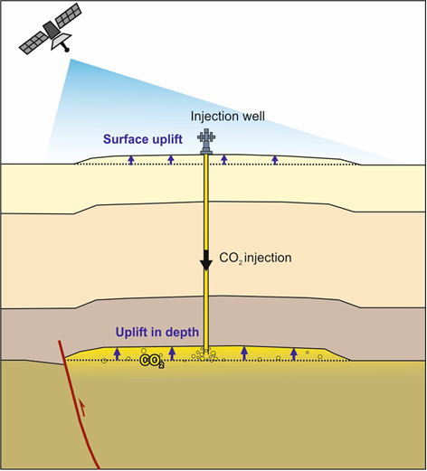
Title: Assuring integrity of CO2 storage sites through ground surface monitoring (619155)

Project owners: Equinor, NGI by project manager Bahman Bohloli, Quad Geometrics and University of Oslo.

The other partners are: GEOMAR (Germany), British Geological Survey (BGS) (UK), IFPEN (France), CIUDEN and Spanish Geological Survey (Spain), Lawrence Livermore National Laboratory and University of Texas, Austin (USA), Research Institute of Innovative Technology for the Earth (Japan), CSIRO (Australia) and KIGAM (South Korea).

Support from the CLIMIT programme: NOK 12.3 million

Project period: 2019 -2022

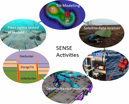
More information: SENSE and forskning.no

More about carbon capture and storage: CCS, the Langskip project and Technology Center Mongstad

footer logo

CLIMIT is a national programme that has been funding research, development, and demonstration of more efficient CCS technologies for 20 years.

Contact
Email: postmottak@gassnova.no
  • linkedin social icon
  • youtube social icon
gassnova © 2025
Web design & Web development by Increo
webmaster Privacy policy